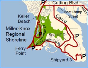
Trains … bricks … ferries … troopships: the 7.1-mile Ferry Point Loop and linked Shipyard 3 Trail represent some of the most historic and scenic sections of the San Francisco Bay Trail.
The Ferry Point Loop encircles 306-acre Miller/Knox Regional Shoreline and is adjacent to the Point Richmond Historic District. The Shipyard 3 Trail is located in Richmond’s Point Potrero Marine Terminal as part of Rosie The Riveter/WW II National Historical Park.
Shipyard 3 is the only place where WW II ship building facilities remain in the U.S., i.e. six buildings and five dry dock basins. as well as the S.S. Red Oak Victory and a Whirley Crane used in the Kaiser shipyards. It includes overlooks from a hillside above the Point Potrero Terminal as well as the historic ship basins with engaging exhibits interpreting Shipyard 3’s role during WWII.
Click here to download the elegant Ferry Point Loop & Shipyard 3 Trail Guide.
On May 31, 2015, the City of Richmond celebrated completion of the Ferry Point Loop Bay Trail on its lands. However, a 0.5-mile shoreline section of Bay Trail remains to be built around the City’s Terminal One property from the end of Dornan Drive looping back to Brickyard Cove Road. This will be built as part of future development on the site, which is zoned for residential use.

View the YouTube Video
A Special Thanks to Richard Lee and Christian Wimmer at Richmond’s own KCRT-TV
Photos above of the Ferry Point Loop Opening by Ken Osborn
On July 2010, East Bay Regional Park District’s (EBRPD’s) Board of Directors appropriated $1,177,000 of Measure CC funds for capital improvements in Miller/Knox Regional Shoreline to “remove tracks, fencing and re-grade railroad right of way to provide public access from the park to the Bay and to Keller Beach, as well as to renovate the meadow area and remove silt & vegetation to keep the lagoon healthy”. However, opposition from Burlington Northern Santa Fe Railroad blocked the project to move the Bay Trail from the lagoon to the western shoreline of the park on land the District bought from Atchison, Topeka and Santa Fe Railroad in 1992. Litigation filed by EBRPD resulted in a favorable ruling by Contra Costa County Superior Court in late 2019. In late 2023, EBRPD released conceptual plans for the Keller Beach Improvement Project with a new section of Bay Trail along the shoreline between Keller Beach and the mid point of the lagoon area and is seeking grant funds to complete the project. The needed next step in to extend the shoreline trail to Ferry Point.
Bicyclist traffic through the Point Richmond Historic District increased greatly with opening of the Richmond San Rafael Bridge Trail and the Richmond San Francisco Ferry Terminal in 2019 accompanied by protected new two-way bikeways on Garrard Blvd. and Ohio St. providing a linkage with BART stations via the Richmond Greenway. The City of Richmond has secured grant funding to make Ferry to Bridge to Greenway Plan pedestrian and cyclist safety improvements through the Point Richmond Historic District between Cutting Blvd. and the Castro St. approach to the Richmond San Rafael Bridge Trail. This $447,000 project will be funded primarily by Surface Transportation Mitigation Program funds provided by West Contra Costa Transportation Advisory Committee and a CA Transportation Development Act grant funded by the statewide general sales tax. The project will widen sections of sidewalk, complete the protected two-way bikeways and Garrard Blvd. & Tewksbury Ave. and improve bus stops, but as of early 2024 had yet to be launched by the City.

A beautiful day at Miller/Knox Park
Read the fascinating “60-year Saga of Miller/Knox Regional Shoreline” >>
Osprey with its huge nest on the Whirley Crane next to the SS Red Oak Victory ShipPhoto by Bruce Beyaert


