POINT MOLATE & RICHMOND/SAN RAFAEL BRIDGE
Thanks to Bay Area Toll Authority (BATA), a 1.1-mile Bay Trail section runs from the Point Richmond Historic District to the Stenmark Drive exit from I-580 where it intersects with the completed Richmond/San Rafael Bridge Trail and the planned Point Molate Trail. This two-way, multi-use trail begins at the intersection of Tewksbury Ave. & Castro St. and crosses under I-580 at Marine St. before continuing to Stenmark Drive.
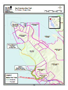
The San Francisco Bay Trail Plan includes a 4.2-mile spur from the Richmond/San Rafael Bridge north along the shoreline through the City of Richmond’s 400+ acre Point Molate property and around the City’s former Terminal 4 at Point San Pablo to terminate at the Point San Pablo Harbor. This is the largest gap in the planned Bay Trail route through Richmond.
East Bay Regional Park District partnered with the City to design and build 2.5 miles of Bay Trail along the shoreline north from the Richmond/San Rafael Bridge past Point Molate Beach Park to the Winehaven Historic District using over $6 million in grants secured by the City and the District. Construction bidding is expected to take place during the first quarter of 2024. The trail will open up a scenic, historic stretch of San Francisco Bay shoreline where there is no public access other than at Point Molate Beach Park.
Richmond/San Rafael (RSR) Bridge Trail
BATA opened the 4.4-mile Richmond/San Rafael Bridge Trail on November 16, 2019 to provide a pedestrian and bicyclist connection between the East Bay and North Bay. This marked the sixth Bay Area bridge with the Bay Trail completed. About 700 bicyclists turned out on November 11, 2024 to celebrate completion of the four-year pilot project. Cumulatively, there were about 360,0000 bicycle and pedestrian trips across the bridge since the trail opened. To date, over 5,200 people have signed Rich City Rides petition to save the trail. An analysis by Bay Area Toll Authority (BATA) staff concluded that the trail had no significant impact on traffic congestion. By mid-year 2024, UC Berkeley’s Partners for Advanced Transportation Technology group will produce a report analyzing the project’s performance, and BATA plans to decide on the the future of the trail by year-end 2024.
.


East Bay bicyclists may reach the trailhead at the intersection of Castro St. and Tewksbury Ave. either by riding the Bay Trail from points as far away as Emeryville or from the Richmond BART station by taking 16th St. to the Richmond Greenway and riding the protected cycle track along Ohio Ave. to the Bay Trail. AC Transit Route 72M and Golden Gate Transit Route 40 buses stop at the Castro & Tewksbury trailhead with connections to BART and SMART, respectively. Golden Gate Transit Route 40 buses traverse the bridge with a stop at the Marin trailhead, offering the opportunity for one-way stroll westward across the bridge and returning by bus.
CLICK HERE to view the Bay Trail Confidential show on the RSR Bridge Trail featuring Andrew Fremier, Metropolitan Transportation Commission Deputy General Manager, Dave Campbell of Bike East Bay and Warren Wells of Marin County Bicycle Coalition.
Point Molate Trail
The Bay Trail Plan, City of Richmond General Plan and EBRPD’s Master Plan all call for completion of the Bay Trail on the San Pablo Peninsula north of I-580. EBRPD and the City have partnered to complete 2.5 miles of Bay Trail along the shoreline between the RSR Bridge Trail and the northern border of the City’s Point Molate property. This includes 1.1 miles of shoreline trail on the easement donated by Chevron plus 1.4 miles on the City’s Point Molate property. EBRPD has funded design plans, approved a Mitigated Negative Declaration under CEQA and applied for the major permits required for the entire 2.5 miles.

The Point Molate Bay trail is fully funded with construction bids to be advertised Spring 2024. This $6.5 million project is made possible by City and EBRPD funds augmented by the following grants:
– $2.2 million Prop. 68 Recreational Trails & Greenways grants
– $2.0 million Plan Bay Area Priority Conservation Area grants
– $0.9 million Recreational Trails Program grant
– $0.3 million Prop. 68 grant from SF Bay Trail Project
POINT MOLATE TO POINT SAN PABLO HARBOR
Chevron has committed to provide EBRPD a trail easement over its land between Point Molate and the City’s former Terminal 4 at Point San Pablo. The situation is complicated by an railroad easement owned jointly by BNSF and Union Pacific railroads. Trail access between the Terminal 4 site and Point San Pablo Harbor also will require access to Chevron land with a railroad easement; however, Chevron has yet to commit to provide a trail easement for this corridor.
Also see the Point San Pablo Peninsula / Point Molate website


