

POINT MOLATE
Point Molate
The 412-acre former Point Molate Naval Fuel Depot (NFD) contains about 276 acres of land above high tide elevation. Located on Richmond’s shoreline about a mile north of the Richmond/San Rafael Bridge, this unique site contains:
- 1.5 miles of shoreline unoccupied with the exception of the City’s Point Molate Beach Park
- A 400 foot high ridge line with sweeping views of two bays, Victorian East Brother Light Station, Mount Tamalpais and Mount Saint Helena
- A 1400 foot long pier providing deep water access
- the 47-acre Winehaven Historic District with a Rhineland-style “castle” that was part of the largest winery in the U.S. prior to Prohibition
- Extensive intertidal eel grass beds and
- Rare coastal prairie and coastal bluff native plant communities.
The City of Richmond owns approximately 70% of the dry land representing chiefly the shoreline and hillside areas. The remaining 30%, including the Winehaven Historic District and sites of former Naval Fuel Depot facilities, are owned by the Guidiville Rancheria of California held in a Delaware LLC called Point Molate Futures LLC.
Point Molate’s great potential was laid out in the Reuse Plan adopted by the City Council in 1999. However, 25 years later, the site remains derelict and fenced off with exception of the Beach Park. Historic buildings continue deteriorating with “demolition by neglect”, and French broom continues invading native plant communities.
Subsequent to adoption of the Reuse Plan by the Richmond City Council, many generalized plans and visions were prepared for Point Molate as described below. Moreover, two different, detailed development plans were prepared at great expense between 2004 and 2022 in reliance upon Land Disposition Agreements awarded by the City Council. Both of these were rejected by the Council amidst great controversy, finger pointing and litigation. Lawsuits are pending challenging ownership and plans for the 80 acres designated for development. Meanwhile, the fate of the 196 acres designated for parks and open space remains in limbo and fenced off with exception of the existing beach park. Click Here for an article describing the history of litigation over the property going back to 2012, including lawsuits still active or with settlements still in effect.
One positive development is that the City and East Bay Regional Park District (EBRPD) have partnered to construct 2.5 miles of San Francisco Bay Trail along the shoreline between the Richmond San Rafael Bridge and the Winehaven Historic District. Click Here for the status of the Point Molate Bay Trail.
On July 18, 2022, Governor Newsom signed state budget bill SB 154 allocating $36 million to EBRPD for acquisition and cleanup of Point Molate. This provides EBRPD with seed money for attempting to negotiate acquisition of the 30% of Point Molate (80 acres) being litigated by Suncal and subject to the settlement agreement of a lawsuit by Upstream Point Molate LLC and the Guidiville Tribe of Pomo Indians as describe below. Presumably the other 70% could be acquired from the City of Richmond.
EBRPD faces a long, difficult process, awaiting resolution of Suncal’s lawsuit against the City of Richmond to determine whether Suncal has the right to purchase the property for $45 million or whether Upstream and the Tribe have the right to acquire it for $400. If EBRPD is able to negotiate acquisition from the property owner, many years will be required to prepare and adopt a Land Use Plan, including a CEQA document, before park improvements can be designed, funded and built to make the property available for public enjoyment. For example, it took the District six years to amend the existing land use plan for Miller/Knox Regional Shoreline.
A series of articles published by Bay Crossings provides an excellent summary of Point Molate’s unique, colorful history and its promising future.

Short History – 1908 to 2020
The 47-acre Winehaven Historic District is recognized under both Federal and State law as the site of The largest winery in the United States before Prohibition.
Beginning in 1942, Point Molate served as a U.S. Navy fuel storage and transfer facility. It closed on September 30, 1995 under the U.S. Department of Defense Base Realignment and Closure Act of 1990. The Navy sold 218 acres of the property to the City of Richmond for one dollar in September 2003. Transfer of the remaining land was completed in March 2010 under an Early Transfer Cooperative Agreement under which the Navy provided the City with $28.5 million for a cleanup approach agreed upon by the parties and the Regional Water Quality Control Board. The cleanup has been largely completed, but monitoring for potential pollutants continues.
_On Nov. 24, 2004 the City of Richmond entered into a Land Disposition Agreement (LDA) with Upstream Point Molate LLC and the Guidiville Tribe of Pomo Indians to sell former Naval Fuel Depot Point Molate for $50 million. In 2011, the Richmond City Council and the Bureau of Indian Affairs rejected the proposed tribal gambling casino following certification of a Final Environmental Impact Report and federal EIS. On February 3, 2015, the federal district court ruled in favor of the City on a lawsuit filed by Upstream and the Guideville Band in 2012. However, the plaintiffs filed an appeal to the Ninth Circuit Court of Appeals. Settlement of the litigation was announced via an April 12, 2018 letter from City Manager Bill Lindsay. Major terms include:
- the The City will make a decision on land use entitlements for Point Molate by no later than April 2020 in a manner that is generally consistent with the Point Molate Reuse Plan, which was first adopted by the City Council in 1997. This deadline was extended due to COVID-10 epidemic and an LDA with new developer Suncal as described below.
- The Reuse Plan includes a development scenario at Point Molate with 670 residential units and preservation of at least 70 percent of the 275 acres at Point Molate as open space.
- The Winehaven Historic District, listed on the National Register of Historic Places, will be preserved for adaptive reuse.
- After it makes a decision on land use entitlements, the City plans to sell parcels at Point Molate within two years.
- Proceeds from the sale of development property at Point Molate will be shared equally between the City and Plaintiffs.
CLICK HERE to view the City Manager’s letter and HERE for the full text of the Court’s Judgement on Claims.


Point Molate Mixed-Use Project – 2020 TO may 2022
On September 8, 2020, the City Council approved entitlements for the Point Molate Mixed-Use Project as proposed by SunCal’s Winehaven Legacy LLC. The approved Disposition and Development Agreement provided that the City will sell to the developer about 80 acres of land representing about 30% of the 276 acres of dry land for $45 million. The remaining 70% (about 196 acres) will be retained by the City of Richmond as shoreline park and open space lands to be operated and maintained initially by the developer an then an association of home and business owners.
On the 80 acres sold, the project will include:
- Restoration and adaptive reuse of the Winehaven Historic District with 318 to 1,098 residential units and 40,000 to 625,000 sq. ft. of general commercial space;
- New residential areas with up to 942 housing units, 15,000 sq. ft. of neighborhood-serving commercial spaces and 10,000 sq. ft. of cultural and/or civic buildings;
- Widening of Stenmark Drive with addition of bicycles lanes from the project site to the I-580 on ramps; and
- Utility and infrastructure needed to support the project, including fire and police stations.
On the 196 acres retained by the City, the project will include
- 35 acres of shoreline park with 1.5 miles of Bay Trail and
- 141 acres of open space with a trail system.
The initial phase of development must include construction, operation and maintenance of the 1.5 miles of San Francisco Bay Trail on the property with an associated 35 acres of shoreline park.
However, Suncal was unable to close escrow by the May 21, 2022 deadline after the City Council refused to approve its proposed Community Facilities District and promptly filed a lawsuit against the City.
City sellS Point Molate developable land for $400
___________________
Failure to sell the developable 80 acres of land to Suncal required the City to sell it to Upstream Point Molate LLC and the Guidiville Tribe of Pomo Indians on August 29, 2022 for $400 per terms of the agreement settling their lawsuit against the City. Upstream and the Tribe, now doing business as Point Molate Futures LLC, will have at least five years to sell the property and split the proceeds with the City. Meanwhile, the City will have an ongoing obligation to bear all expenses of maintaining and securing the Property.
")

Natural Environment
Bay Nature magazine featured the natural world of Point Molate in the article “Betting on Point Molate” by Chiori Santiago. In particular, Native Plants are real survivors at Point Molate. The uplands of Point Molate are distinguished by coastal terrace prairie and northern coastal bluff scrub plant communities where the major conservation issue is unmanaged invasive alien plants. The inter tidal zone is distinguished by abundant eelgrass beds and a variety of kelp. It is mostly rocky with the exception of sand/mud flats offshore Point Molate beach.
The September, 1998 Special-Status Plant Survey And Habitat Assessment report for Point Molate NFD, which was prepared by Michael Wood of Sycamore Associates and Tetra Tech, states:
• “numerous plant taxa of botanical significance do occur on site;”
• “Coastal terrace prairie and northern coastal bluff scrub habitats are exceedingly rare in the East Bay and represent diminishing habitats throughout their range;”
• “the native perennial grasses …. exhibit very high levels of density and diversity. Native grasslands of comparable quality are extremely uncommon in the East Bay, as well as in more coastal areas in Marin County;”
• “the diversity of wildflowers in the grasslands is also unusual in the region.”


Point Molate Beach Park Reopened October 14, 2013
Plans for Point Molate
The Richmond General Plan 2030 designates the former Point Molate Navy Fuel Depot area as a combination of Business/Light Industrial, Medium-Density Residential, Low- Density Residential, Open Space and Parks and Recreation to reflect the conceptual land uses in the adopted 1997 Point Molate Reuse Plan.
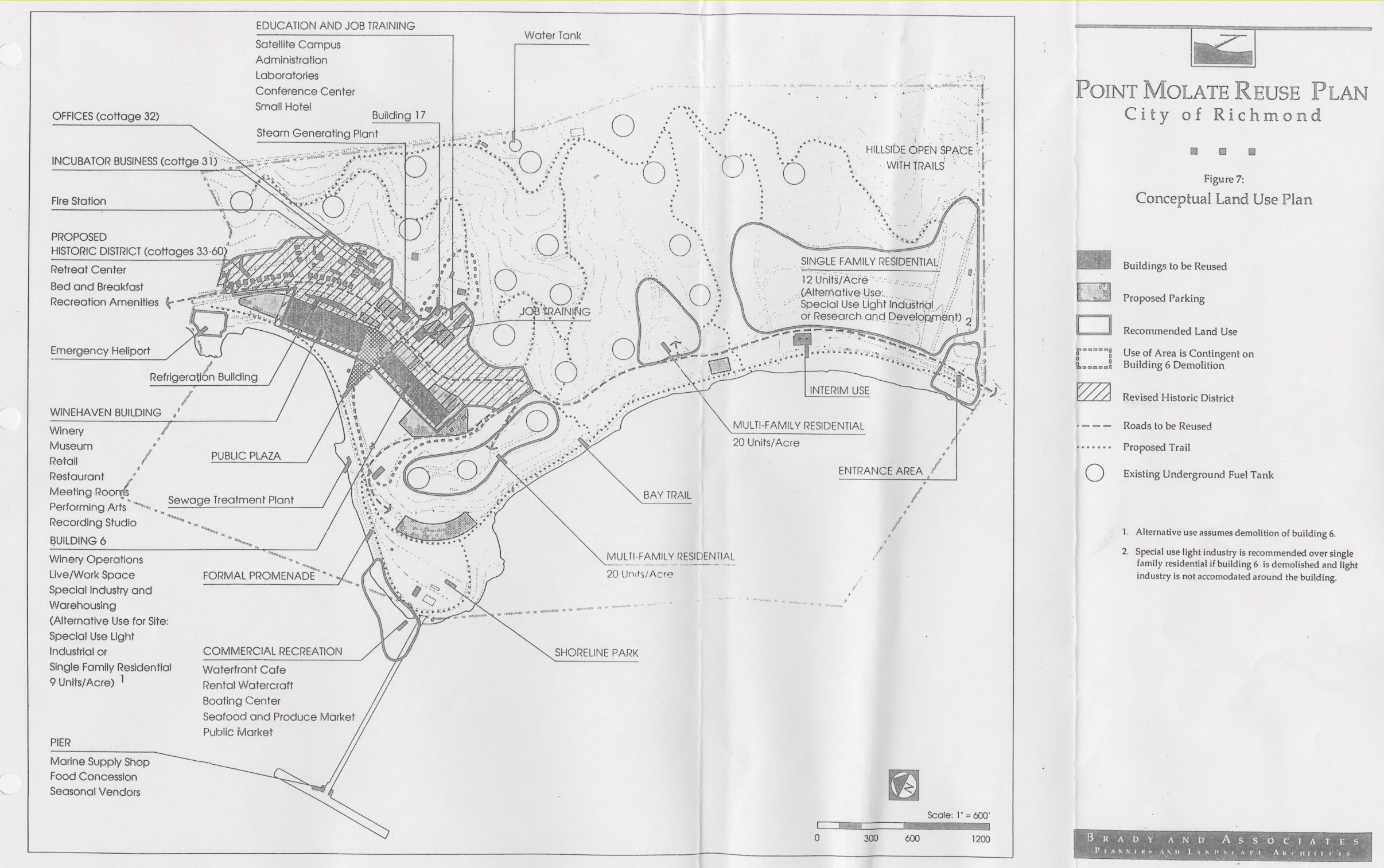
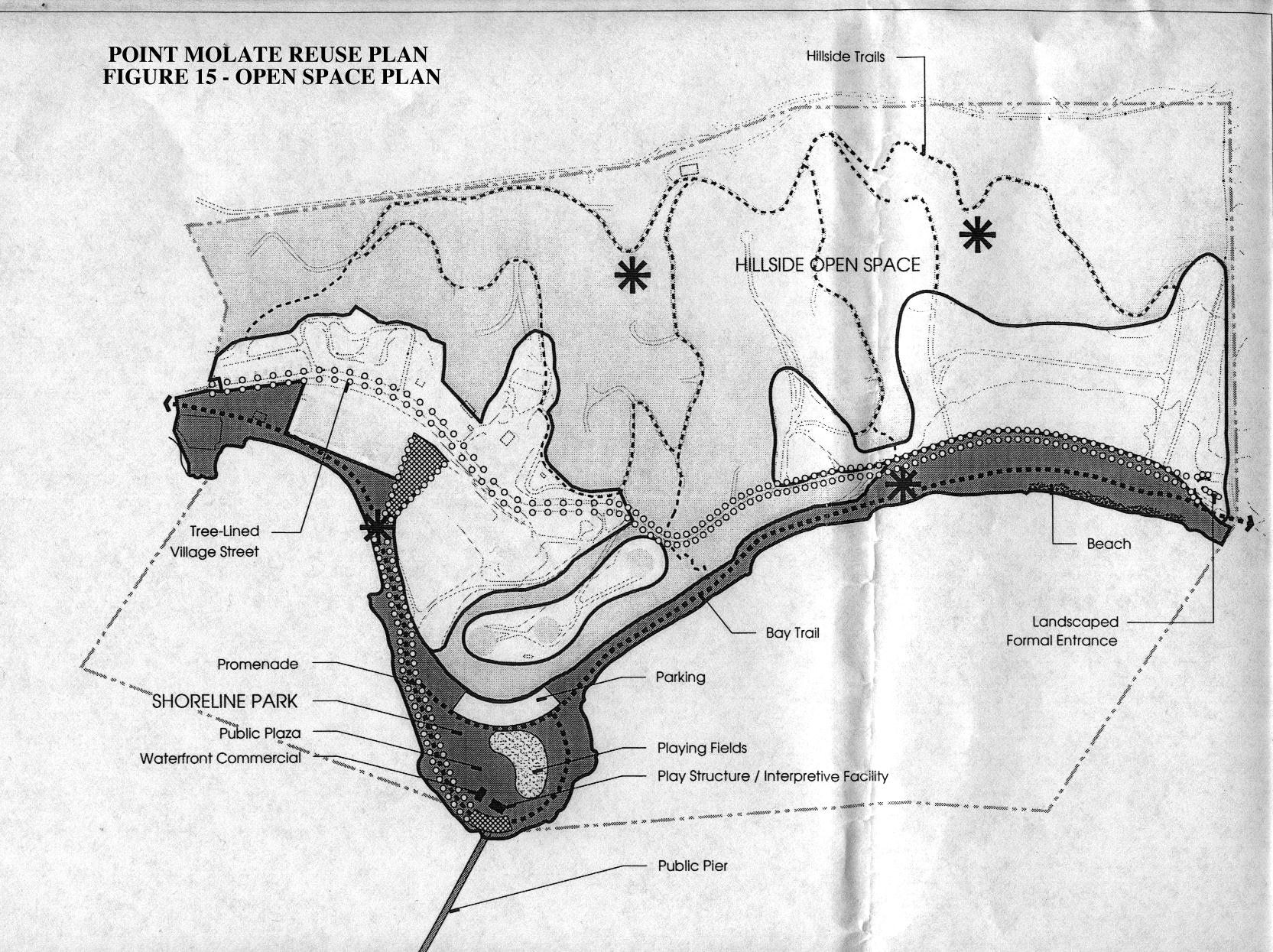
The Point Molate Reuse Plan was developed by a 45-member Blue Ribbon Advisory Committee and approved by the City Council in 1997 acting as the Local Reuse Authority to serve as the guide for the reuse and development of the site. It calls for a mixed use development concept with 191 acres reserved for shoreline park and hillside open space lands as shown on the Conceptual Land Use Plan and Open Space Plan.
Uses proposed for buildings in the Winehaven Historic District include:
- Winehaven Building – winery, restaurant, museum, retail, meeting rooms, performing arts and a recording studio
- Historic winery cottages – conference center, retreat, B&B, classrooms.
Existing buildings on a 20-acre site immediately south of Winehaven are proposed for a winery, live/work, warehousing, job training and light industrial uses. Single and multifamily residential development is recommended on about 38 acres of relatively flat land south of the above development areas.
On Oct. 23, 2018, the City Council adopted a Point Molate Vision with conceptual design studies to serve as a framework for development proposals. This Vision is based upon an extensive process conducted during 2018 seeking community input about how to best use the land at Point Molate for the benefit of all. Key areas for visioning included restoration and adaptive reuse of the Winehaven Historic District and locations for the minimum of 670 houses required under settlement terms of litigation challenging the City’s denial of the proposed gambling casino. The settlement requires developing the property in a manner that is generally consistent with the Point Molate Reuse Plan (Reuse Plan), which was first adopted by the City Council in 1997 and incorporated in large part into the City’s General Plan 2030.
Implementing Plans for Point Molate
“… the potential economic development program for Pont Molate should have a recreations/leisure, hospitality, and residential focus. Specifically, identified uses include a hotel with moderate amount of conference and event space, a restaurant, and possibly camping facilities, supported by accessory recreation uses. Other uses include rental apartments and one or more wineries.”
• Tough choices based on political and economic limitations of the site, but limitations provide clear framework for path forward• Status Quo faces increasing costs based on continued and significant deterioration• The City should partner with East Bay Regional Park District
• Trade offs:
– Role of the historic structures – targeted focus needed
– Role of Commercial/Industrial Uses
– Role of Housing as a driver
• All uses will need to be investigated in more detail. Park Plus option is immediately attainable, but won’t provide infrastructure. The mixed use option is the clearest path to realize the highest site potential.
CLICK HERE to view the ULI report offering guidance for moving forward with Point Molate development.
Getting Involved
To keep up to date on development proposals, CLICK HERE and sign up to receive agendas of the City Council.